Methodological Aspects Regarding the Planning and Development of Integrated Tourist Routes and Circuits. Case Study: Luncasprie, Romania
Grigore Vasile HERMAN1*, Lucian BLAGA1
1. University of Oradea, Faculty of Geography, Tourism and Sport, 1 Universitatii Street, 410087, Oradea, Romania, e-mails: grigoreherman@yahoo.com, blagalucian2008@yahoo.com
* Corresponding author
Citation: Herman, G.V., & Blaga, L. (2022). Methodological Aspects Regarding the Planning and Development of Integrated Tourist Routes and Circuits. Case Study: Luncasprie, Romania. Geosport for Society, 17(2), 120-133. https://doi.org/10.30892/gss.1705-088
Article history: Received: 21.10.2022; Revised: 12.11.2022; Accepted: 21.11.2022, Available online: 29.11.2022
Abstract: The intensification of tourist activities at the level of the Bihor Tourist Destination, in parallel with the increase in the need to diversify the local tourist offer, led to the need to identify new solutions in this regard. Due to the geographical location of the studied area, in the immediate vicinity of the Oradea Municipality, this space, due to the values with which it is endowed with the natural environment and the existing tourist infrastructure, can be constituted as a viable alternative with a role in reducing the tourist pressure in the Oradea area and in diversifying the tourist offer through rural tourism and agritourism. In this context, the present study aims to propose integrated tourist routes and circuits following the analysis of the local tourist potential. The results obtained consisted in carrying out an analysis of the natural environment from a tourism perspective and making some development proposals (three routes and a tourist circuit).
Keywords: tourist route, tourist circuit, territorial planning, rural tourism
Introduction
The rural area is the result of the multi-millenary cooperation between man and nature. Over time, the rural space has known a series of structural and functional changes, which have been induced to the rural space, constantly, almost imperceptibly on the scale of historical time, against the backdrop of the technological advances that humanity has made. However, in the last period of time, characterized by intensive industrialization and cutting-edge technology, the contribution of structural and functional changes in the rural area has also seen significant progress. Among these, we can mention the actions in the direction of increasing the production capacity of the land (water improvements, terracing, etc.) and the improvement and modernization of the rural habitat (the development of communication routes, the introduction and development of technical and building facilities, the implantation in the rural area of some activities non-agricultural) (Herman, 2009).
If until yesterday, the rural environment was a space for carrying out agricultural and pastoral activities and for the residence of the population that took care of these activities, against the background of the progress recorded, it is diversifying from a structural and functional point of view, acquiring new connotations and functions between which those with specific industrial, commercial, relaxation, recreation and residence for the non-agricultural population.
Globally, due to the importance of rural space in supporting humanity by providing food resources and raw material for industry, the definition of the concept of rural space knows a multitude of approaches that differ from country to country. The most intensively circulated criteria in the differentiated approach to the concept of rural space are: economic (agricultural activities, processing industry), sociological (specific way of life, behavior and value system distinct from the urban one), geographical (way of occupying space, way of living) (Candea et al., 2006).
From a structural point of view, the geographical space includes the following elements: the population, the rural settlement and the adjacent land. Among the previously listed components, the rural settlements are subject to the tourist development process. Just as in the case of the definition of the concept of rural space, and in the case of the definition of the notion of rural settlement, at the global level, there is a wide range of approaches, in this sense. Among the most frequently used criteria, we mention the "statistical, administrative, legislative, functional, etc." (Candea et al., 2006, p. 112). At the level of the European Union, the criterion used to separate rural settlements from urban ones is the density of inhabitants / km2. In Romania, the status of human settlements (rural and urban) is regulated by law, regardless of their demographic size and population density. So, this is the context in which tourism asserts itself in the Romanian countryside through rural tourism and agritourism.
Rural tourism is a niche form of tourism that takes place in rural areas and is defined by specific activities and services, including accommodation and meals; "strong socialization with the family of the guesthouse owner"; "integration and active participation in household activities"; "informing, preparing and accompanying tourists to recreational activities and cultural actions"; "guide in the village and outside the village" (Dincă et al., 2012, p. 44).
Agritourism is a form of tourism that takes place in the countryside and involves only the performance of a part of the activities and services related to rural tourism, namely: accommodation and meals; "strong socialization with the family of the guesthouse owner"; integration and active participation in household activities (Dincă et al., 2012, p. 44).
From the comparative analysis of the two notions, namely the notion of rural tourism and agritourism, the following conclusions can be drawn: both types of tourism are carried out and are specific to rural areas; in terms of the activities and services provided within the two types of tourism, there is an overlap of them, rural tourism incorporating all agritourism activities and services, plus other specific activities and services.
Rural tourism and agritourism has been imposed in the last period of time also in Romania against the background of the following motivations: "return to unmodified nature", "knowledge and temporary adherence to groups of belonging specific to rural areas", "knowledge, understanding" and "direct contact with pieces of the treasury of national history, folklore, traditional occupations and popular customs", "aesthetic motivations arising from the need for beauty, order, purity, harmony, naturalness", "curiosity satisfied by information on popular hospitality, gastronomic habits, handicrafts and rituals village", "rest, air and fruit cure, consumption of fresh food and occupational therapy", "sport, hunting, sport fishing, ascents and hiking" (Erdeli and Gheorghilaș, 2006, p. 243).
The satisfaction of all the demands of tourists arising from motivational aspects, through rural tourism and agritourism, within rural settlements in Romania and beyond, is conditioned by the following determining factors: "orographic, climatic and biogeographical characteristics; the location of the locality in relation to the main tourist circulation axes; the degree of development and modernization of the infrastructure and means of transport; the presence of original or unique attractive resources, belonging to the natural setting (geological, speleological, biogeographical, etc.), cultural (traditions, customs, popular customs, activities and traditional architecture) or historical (historical, cultural, architectural objectives) etc.)" (Ciangă and Deszi, 2007, p. 245).
The analysis of all these determining factors at a general and particular level constitutes a premise and a preliminary step in order to start the procedures regarding the planning and tourist development of the rural area. The main beneficiaries of such efforts will be directly "Local public authorities; Non-profit and non-governmental associations in the locality or region; Tourist service providers; Local population" and indirectly "National Tourism Authority, Tour operators; County Council" (Ilieș, 2007, p. 52).
Although we benefit from a significant rural fund, with many rural settlements, not all of them lend themselves to their development from a tourist point of view. The abundant presence of various attractive resources in the rural area does not constitute a certainty and a guarantee of the viability of the implementation of a tourist development plan for the respective place. As a rule, in the planning and development of tourism in a rural locality, the following essential and vital aspects are assumed: access roads, technical and building facilities (electricity, running water, sewage network, gas, landline or mobile telephony, internet etc.) and other local public services (pharmacy, post office etc.). Another aspect, as important as the previous ones, when we talk about the planning and development of a rural locality is the legislative framework. It is made up of a multitude of legal acts (laws, government decisions, emergency ordinances, local decisions and decisions, etc.) that direct the way of organization and systematization of the territory, in general, and of future tourist developments, in particular (Dincă et al., 2012, p. 250). Among these, we mention those regarding the development of: the territory (Law 350/2001); ski slopes (Decision 263/2001; Order 491/2001); mountain tourist routes (Decision 77/2003); beaches (OG 19/2006; Order 1204/2010); tourist reception structures with public catering accommodation functions (Order 65/2013; Order 221/2015), tourist information and promotion centers (Order 1096/2008) and tourist resorts (Decision 852/2008).
Tourist localities are extremely important tourist destination spaces for rural tourism, being characterized by a series of specific elements: small community, special activities and occupations, clean environment, etc. These characteristics determined and supported the expansion of tourism in the countryside.
The diversification of the tourist offer and the optimal exploitation of the tourist potential of a certain area, at a given moment, calls for sustained efforts from the interested parties (local public authorities, ministerial structures, NGOs, tourist service providers, specialists from various fields of activity etc.) in the direction of planning and setting up integrated tourist routes and circuits.
In this context, the purpose of the present study is the analysis of the natural and anthropic framework related to the rural town of Luncasprie, in Bihor County, Romania, in order to make proposals for integrated tourist routes and circuits, with a role in directing tourists in a territorial profile and in the interconnection of the local tourist offer. Thus, a high-performance and operative arrangement can be contained in a factor generating qualitative changes at a mental level for the local community and tourists alike, and last but not least in a business card of the destination it represents (Dincă et al., 2012).
From a conceptual point of view, the tourist route and circuit represent the route or path on which potential tourists are guided to move in order to carry out the touristic act, for physical and mental recovery, relaxation, rediscovery, contemplation, knowledge etc. The act of tourism involves walking or cycling (Ilieș et al., 2013) along a predetermined route, during which the tourist will encounter a series of objectives, the purpose of which is to arouse and maintain interest. According to the specialized literature, "walking in the open air involves the movement of potential tourists, on foot, from point A to point B, following a certain route for recreation, physical and mental recovery and tourist discovery. These points are not strictly imposed, they are defined in space by a series of characteristics among which the place where the tourist is staying, his needs at a given moment, his preferences for one route or another, etc. stand out" (Dincă et al., 2012, p. 271), while, "cycling tourism is a form of active tourism that involves the movement of potential tourists with the help of a bicycle, from a point A to a point B, following a certain route in order to recreation, physical recovery psychic and tourist discovery" (Dincă et al., 2012, p. 276).
The difference between the notions of "integrated thematic route" and "integrated thematic circuit" consists in the functionality and operability of the latter, to lead tourists from a starting point "A" to that point "A", but on a separate route, avoiding in this way a possible loss of interest on the part of tourists or even their boredom. In the case of thematic routes, there is the possibility that tourists will be guided from a point "A" to a point "B", where the tourist act is to end or their return on the same route from point "B" to point "A". Regarding the "integrated" attribute of those two concepts, previously defined, respectively "integrated thematic route" and "integrated thematic circuit" are derived from one of the fundamental principles according to which the tourist planning and development activity is marked, respectively from the "integration principle". Just as "tourist planning and development" is an integral part of the wider process of "territorial planning and development", so too "planning and development of tourist routes and circuits" is an integrated part of "tourist planning and development".
Research methodology
The studied area
The locality of Luncasprie is located in the Dobrești territorial administrative unit, Bihor County, Romania. From an orographic point of view, the analyzed area is located in the South-Western part of the Pădurea Craiului Mountains, being crossed in a North-South direction by Valea Vida (Figure 1).
Materials and methods
The information necessary for the development of the present study was obtained through the tourist prospecting method in two distinct stages, the office stage and the field stage (Herman et al., 2016a, b; Caciora et al., 2019; Oanț and Herman, 2022). In the office stage, the specialized references and existing cartographic materials were consulted, the graphic / cartographic materials were drawn up and the related documentation was drawn up. In the field stage, photographs, observations and measurements were taken and recorded in the worksheets used.
The main aspects taken into account in making the proposals (three routes and a tourist circuit) in the present study were the relief, the hydrography, the access roads, the spatial distribution of the households (with their related land) and that of the existing tourist objectives.
The relief is the basic element in making such proposals, through its roles of support and generating factor of touristic motivation. In this context, the elevation, fragmentation and configuration of the relief were analyzed, through the prism of the favorability and the restrictions it imposes on the spatial level of the tourist act, in this case walking and hiking.
The hydrography, represented by the Vida river and the reservoir of the same name, with a north-south layout, represents the backbone of the Luncasprie locality, with all the households gravitating to one side and the other of it. Over time, the Vida River represented a precious source of water supply for domestic and agricultural needs. Currently, in the context of the imposition of tourism, in the studied area, it can also receive touristic functions.
The access roads were studied through the lens of quantitative and qualitative characteristics at the spatial level. They have a role in facilitating the movement of potential tourists along established routes and routes. Thus, at the level of the Luncasprie locality, 48.3 km of communication roads were analyzed, of which 14.2 km (30%) are paved, the remaining 34.1 km (70%) are dirt and stone roads (Figure 1).
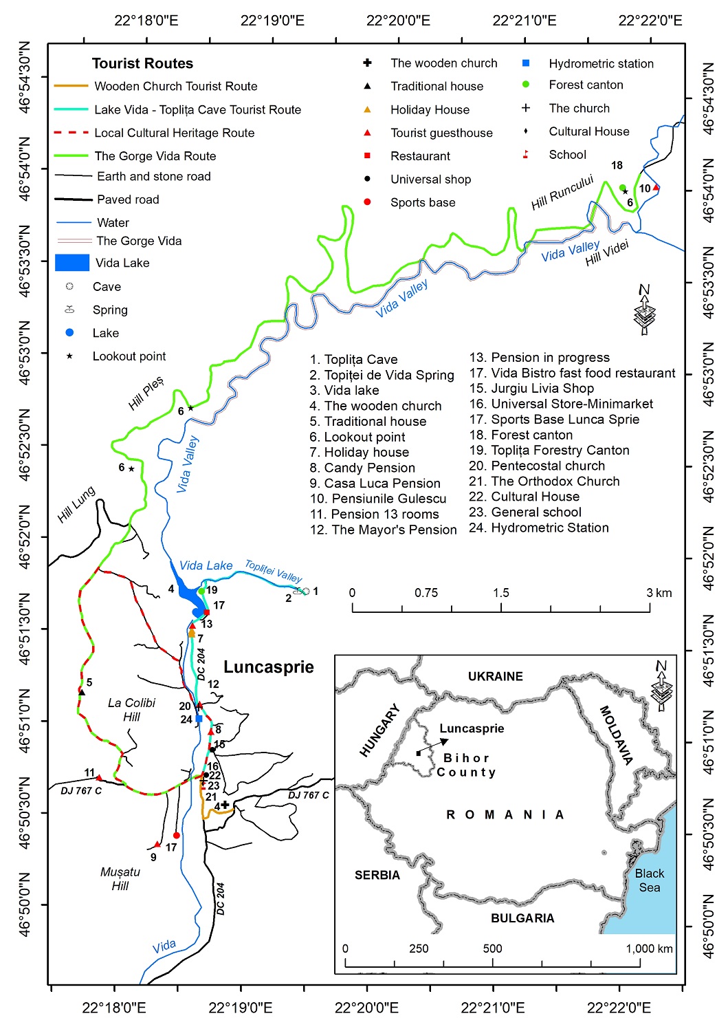
Figure 1. Touristic map
The integrated territorial profile analysis of the households and related lands highlighted the existence of close interdependencies between them, the configuration of the relief, the spatial distribution of the hydrographic network and that of the communication routes.
The spatial distribution of tourist attractions was the key element in establishing the routes and the tourist circuit in Luncasprie. Thus, depending on their spatial location and the favors and restrictions induced by relief, hydrography, communication routes and households with the related land, the present proposals (three routes and a tourist circuit) with a length of 36.7 km were made.
The cartographic materials used were Topographic Map 1:50,000, DEM, Satellite Images. The software used was ArcGis 10.6.
RESULTS AND DISCUSSION
Tourist potential
"The raw material of tourism is space" (Iațu and Muntele, 2003, p. 63), with the two related components, the natural framework (relief, hydrography, climate, vegetation and fauna) and the anthropic one (material and immaterial cultural heritage).
The natural framework is the support for the development of the touristic act, on the one hand, and the generating factor of touristic motivation, on the other. Seen from this perspective, in the process of arranging tourist circuits and routes, it is necessary to carry out a thorough, detailed study, which covers all structural, functional and relational aspects.
The structural aspects will refer to the defining components, which are included in the structure of the natural framework: the abiotic environment (relief - the Vida depression, hydrography - the Videi Valley, the Vida reservoir from Luncasprie) and the biotic environment (plants and animals - specific to the temperate continental climate of the floor of deciduous forests).
Separating the functional aspects from the relational ones is an action with a high degree of sensitivity, because between them there are close relations of interconditioning and interpenetration. However, we can state that the functional aspects will capture as much as possible the role and importance of each element in shaping the analyzed natural system, while the relational ones will try to capture the relationships (conditions) that each individual element develops.
The anthropic framework is represented by human population and settlements. The analysis of the anthropic framework concerned, in this case, the brief analysis of the population and the settlement of Luncasprie where three routes and a tourist circuit were proposed for development, in close correlation with the maximum limit of the degree of bearability, vis-a-vis the number of potential tourists that they can assimilate and support without disturbing the natural gait and good functionality.
Documentarily attested in the year 1508, Luncasprie has known over time an upward, relatively constant evolution, similar to the localities in the Romanian countryside, in terms of the number of inhabitants and the tangible and intangible heritage created by them. In terms of the number of inhabitants, the peak was reached in 1992 (1072 inhabitants), after which the tendency was to decrease until now (Varga, 1999).
Among the testimonies of the architectural heritage created by the local community, the following stand out: the wooden church dedicated to the patron saint "Saints Archangels Michael and Gabriel", the Luncasprie Orthodox Church, the Bethany Luncasprie Pentecostal Church, the households of the inhabitants, the premises of the grocery stores (Universal Store-Minimarket and Jurjiu Livia Shop) and Vida Lake.
The wooden church dedicated to the "Saints Archangels Michael and Gabriel" represents a time capsule through which a series of specific, local particularities are recorded and reproduced regarding: financial possibilities, local beliefs, customs and traditions and last but not least by the technical and technological advances achieved by the society of the time when the place of worship was built. Considering its antiquity (1725) and the previously mentioned reasons, in 2010 this place of worship was included in the list of historical monuments with the LMI code: BH-II-m-B-01169 (List of historical monuments, 2015).
The Orthodox Church is the silent witness of the economic, social and political developments and progress registered in the town of Luncasprie. It is the guarantor of the continuity of the faith of race and language, a guiding beacon in troubled times, of hard trial in which non-values are confused and merge easily with values. At the same time, the Orthodox church is still tributary to some traditions and customs that come from the past, being less open to new things, to new things, something that facilitated the ascent of other cults in an Orthodox space par excellence.
The Bethany Luncasprie Pentecostal Church highlights the changes that took place within the local community in relation to faith, changes that were in close correlation with what happened at the level of the whole country against the background of the expansion of the new cults (Pentecostal and Baptist).
The households of the inhabitants represent the pure expression of the communion between man and nature. Over time, she also underwent major functional and aesthetic changes. Thus, if at the beginning the traditional household was composed of a house, stable, outhouse and other annexes, nowadays, it is structured from a house, a garage and other annexes. In turn, each structural element has undergone quantitative and qualitative structural changes.
The Vida de la Luncasprie dam was built in the northern part of the town of the same name for economic reasons in 1967. The unique element of this lake, in addition to the exceptional landscape offered by the natural setting, is the ingenious solution to evacuate the surplus water through a funnel-type system that connects to Vida Creek downstream through a tube that crosses the lake levee underground in a north-south direction.
Also in the category of local architectural heritage can be included the cultural home, the two forestry cantons, the premises of the grocery stores and the tourist guesthouses. Of these, special attention must be paid to tourist guesthouses because they are essential markers of tourism. Tourist guesthouses appeared and developed in close correlation with the attractiveness of existing tourist resources, as well as the financial capacity of local investors. Thus, there are currently six pensions, of which three are functional (Candy Pension, Casa Luca Pension, Gulescu Pension) and three are being completed (The Mayor Pension, 13 Rooms Pension, Pension in progress).
These structures with accommodation functions foreshadow the insertion in the analyzed space of a new occupational activity, namely tourism. Tourism can represent an important alternative in the development of the local economy, considering the possibilities of spending free time in the most pleasant way, far from the city bustle, offered by the natural and anthropic environment. The development of the local economy through tourism can aim at the following aspects: creating new jobs, reducing unemployment, stopping migration to the urban environment by fixing the young population in the rural environment, increasing the standard of living, attracting new investments in infrastructure, etc. So, this is the context in which the present study was imposed.
Arrangement proposals
Following the analysis of the natural and anthropic framework related to the area of the town of Luncasprie, three proposals were made for tourist routes (Wooden Church Tourist Route, Lake Vida - Toplița Cave Tourist Route, The Gorge Vida Route) and one for a tourist circuit (Local Cultural Heritage Route).
Each of the proposals made, at the level of the Luncasprie locality, are defined by several parameters, among which the route or route of travel, the name, the marking, the length, the difficulty of the route and the duration of the tourist action and the purpose (Ilieș et al., 2013; Dincă et al. , 2012; table 1, figures 1-5).
The travel route related to tourist routes and circuits represents the contact surface between tourists and the elements of the environment. In the field, it is identified with the road / path on which the potential tourists are going to travel.
In order to better orient the tourist, each proposed route benefits from a name (derived from the name of the main tourist attractions they interconnect) and a conventional sign or marking, rendered by a continuous or broken line of various colors and thicknesses (Table 1, Figures 1 -5).
At the level of the studied area, four proposals were made for tourist routes with a length of 36.7 km, which represents a duration of the tourist action of 14.5 hours (Table 1).
The level of difficulty of the proposals made oscillates between easy and medium (Table 1). In establishing their degree of difficulty, three essential parameters were taken into account, namely: length, level difference and type of running surface (ground, asphalt). The Gorges Vida Route is defined by an alternation of sections with different degrees of difficulty (easy, medium), values imposed by the difference in level, the configuration of the relief and the running surface (earth and stone). We also mention that the indicator called the level of difficulty contains a certain dose of subjectivity, induced by age, gender, physical condition, the time required to contemplate the touristic objectives encountered, etc.
The duration of travel for potential tourists along the proposed routes varies between 1.5 hours (Wooden Church Tourist Route) and 7 hours (The Gorge Vida Route). It should be noted that, just as in the case of establishing the degree of difficulty, in this case also the subjectivity notes specific to the level of difficulty persist (Table 1).
Table 1. Proposals for the studied area
|
No. |
Name |
Tipe |
The length (km) |
Duration of the action (h) |
Degree of difficulty |
|
1 |
Wooden Church Tourist Route |
Route |
1.65 |
1.5 h |
easy |
|
2 |
Lake Vida - Toplița Cave Tourist Route |
Route |
6.5 |
3 h |
easy |
|
3 |
Local Cultural Heritage Route |
Circuit |
6.1 |
3 h |
easy |
|
4 |
The Gorges Vida Route |
Route |
30.6 |
7 h |
medium |
|
Total |
36.7 |
14.5 h |
|
||
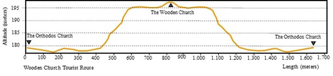
Figure 2. Wooden Church Tourist Route
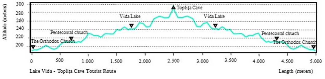
Figure 3. Lake Vida - Toplița Cave Tourist Route
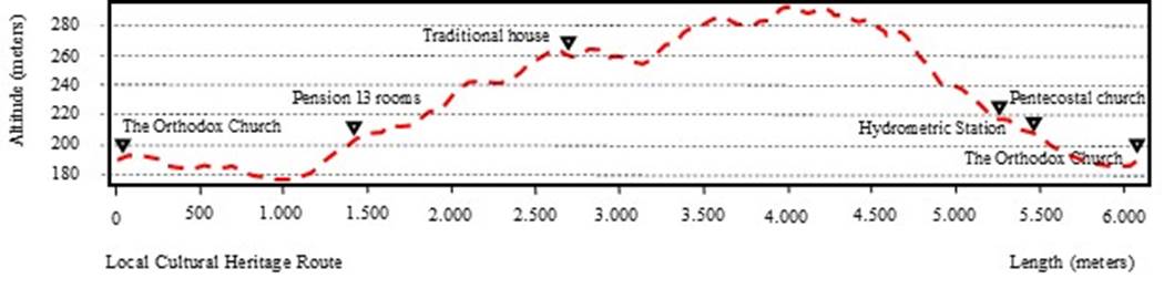
Figure 4. Local Cultural Heritage Route
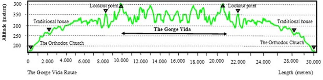
Figure 5. The Gorge Vida Route
Conclusions
The arrangement of tourist routes and circuits are intended to diversify and interconnect the tourist offer of a tourist destination, contributing to the expansion of the retention interval of tourists in the destination of Luncasprie, Romania. Through their design and architecture, they play an essential role in capitalizing on relatively isolated tourist attractions by interconnecting them along travel routes. Moreover, in this way the random movements of potential tourists in the studied area will be restricted, contributing to a better protection and conservation of the biodiversity of the respective site.
The objectives of tourist interest represent both an essential structural element of the arrangements of the integrated thematic tourist routes and circuits, as well as a motivational factor, with functions in triggering the development of the tourist act. From a typological point of view, they can be classified into various objective categories depending on the reference element taken into account. Among the objectives capitalized on by arranging the routes and integrated thematic circuits, we mention the anthropogenic ones (Wooden Church, Orthodox Church, Pentecostal Church, Vida Lake etc.) and natural ones (Toplița Cave, Izbucul Topiței de Vida, Chei Videi etc.).
Currently, in Romania, we cannot speak of a complete legislative framework, which would regulate the aspects regarding the development of integrated thematic tourist routes and circuits. A particular approach to the present issue is developed within "Decision No. 77 of January 23, 2003, regarding the establishment of measures for the prevention of mountain accidents and the organization of rescue activities in the mountains" in which the aspects regarding the development, homologation and maintenance of mountain tourist routes are detailed (Chap. 2, Section 1, art. 27 - 35). Considering that the mountain tourist routes represent a separate category, which only concerns the mountain space, it is necessary to adopt a unified methodology for the arrangement, homologation and maintenance of the thematic tourist routes and circuits (from the tourist destination areas, located on different altitudinal steps etc.), at national and international level.
Currently, at the National Tourism Authority, a number of 952 mountain trails are registered and approved, distributed in the following mountain units: Baraolt, Bodoc, Bucegi, Călimani, Candrel, Ciucaș, Domoglet, Făgăraș, Giumalău, Leaota, Lotru, Pădurea Craiului, Perșani, Piatra Craiului, Piatra Mare, Postăvarul, Rărau, Retezat, Turiai, Vlădeasa, Bargăului, Bihor, Brețcului, Căpățănii, Cernei, Ciomatu Mare, Giurgeu, Ghurghiu, Gutai etc. (Approved mountain tourist routes, 2021).
References
Armstrong, N., & Welsman, J. (1996). Young people and physical activity, Oxford: Oxfors University Press, Lincoln, United Kingdom.
Caciora, T., Herman, G.V., & Keri, G. (2019). Prospect Study of the Cellars in Sălacea, Bihor County, Romania. Analele Universităţii din Oradea, Seria Geografie, 29(2), 40-45.
Candea, M., Bran, F., & Cimpoieru, I., (2006). Organizarea, amenajarea şi dezvoltarea durabilă a spaţiului geografic [Organization, planning and sustainable development of the geographical space], Editura Economică, Bucureşti.
Ciangă, N., Dezsi, Şt., (2007). Amenajare turistică [Tourism planning], Editura Presa Universitară Clujeană, Cluj-Napoca.
Dincă, I., Herman, G.V., Sztankovics, G. (2012). Descoperire prin ecoturism si prin turism rural in Comuna Cetariu [Discovery through ecotourism and rural tourism in Cetariu Commune], Editura Universităţii din Oradea.
Erdeli, G., & Gheorghilaș, A. (2006). Amenajări turistice [Tourism plannings], Editura Universitară, București.
Herman, G. V. (2009). Omul şi modificările antropice din Campia Someşului [The man and anthropogenic changes in Somes Plain], Editura Universităţii din Oradea.
Herman, G. V., Ilieș, D. C., Baias, Ș., Măduța, M. F., Ilieș, A., Wendt, J., & Josan, I. (2016a). The tourist map, scientific tool that supports the exploration of protected areas, Bihor County, Romania. GeoSport for Society, 4(1), 24-32.
Herman, G.V., Ilieș, D.C., Măduța, M.F., Ilieș, A., Gozner, M., Buhaș, R., Mihok-Geczi, I-M-T. (2016b). Approaches regarding the importance of Natura 2000 sites' settings pupil's education through geography. Case study:Valea Rose (Red Valley) Natura 2000, Bihor country, Romania. Journal of Geography, Politics and Society, 6(4), 57-62.
Ilieş, D. C., Herman, G. V., Dehoorne, O., & Măduţa, F. (2013). The role of the importance of cyclotourism in the development of the Oradea Metropolitan area (Romania). GeoJournal of Tourism and Geosites, 12(2), 101-110.
Ilieş, M. (2007). Amenajare turistică [Tourism planning], Editura Casa Cărţii de Ştiinţă, Cluj Napoca.
Ministry of Culture. Lista monumentelor istorice [List of historical monuments]. Available online: http://www.cultura.ro/sites/default/files/inline-files/LMI-BH.pdf (accessed on 20 September 2022).
Ministry of Entrepreneurship and Tourism. Hotărarea 77 din 23 ianuarie 2003 privind instituirea unor măsuri pentru prevenirea accidentelor montane şi organizarea activităţii de salvare in munţi [Decision 77 of January 23, 2003 regarding the establishment of measures for the prevention of mountain accidents and the organization of rescue activities in the mountains]. Available online: http://legislatie.just.ro/Public/DetaliiDocument/41760 (accessed on 20 Octomber 2022).
Ministry of Entrepreneurship and Tourism. Hotărarea nr. 263 din 22 februarie 2001 (republicată) privind amenajarea, omologarea, intreţinerea şi exploatarea partiilor şi traseelor de schi pentru agrement [Decision no. 263 of February 22, 2001 (republished) regarding the arrangement, homologation, maintenance and operation of slopes and ski trails for leisure] Available online: http://legislatie.just.ro/Public/DetaliiDocument/27132 (accessed on 20 Octomber 2022).
Ministry of Entrepreneurship and Tourism. Hotărarea Nr. 77 din 23 ianuarie 2003, privind instituirea unor măsuri pentru prevenirea accidentelor montane şi organizarea activităţii de salvare in munţi [Decision No. 77 of January 23, 2003, regarding the establishment of measures for the prevention of mountain accidents and the organization of rescue activities in the mountains]. Available online: http://legislatie.just.ro/Public/DetaliiDocument/41760 (accessed on 20 Octomber 2022).
Ministry of Entrepreneurship and Tourism. Hotărarea nr. 852 din 13 august 2008 pentru aprobarea normelor şi criteriilor de atestare a staţiunilor turistice (actualizată pană la data de 23 februarie 2017) [Decision no. 852 of August 13, 2008 for the approval of the rules and criteria for the attestation of tourist resorts (updated until February 23, 2017)]. Available online: http://legislatie.just.ro/Public/DetaliiDocument/96733 (accessed on 20 Octomber 2022).
Ministry of Entrepreneurship and Tourism. Ordinul 65/2013 pentru aprobarea normelor metodologice privind eliberarea certificatelor de clasificare a structurilor de primire turistice cu funcțiuni de cazare și alimentație publică, a licentelor si brevetelor de turism [Order 65/2013 for the approval of the methodological rules regarding the issuance of classification certificates of tourist reception structures with accommodation and public catering functions, of tourism licenses and patents]. Available online: http://legislatie.just.ro/Public/DetaliiDocument/148944 (accessed on 20 Octomber 2022).
Ministry of Entrepreneurship and Tourism. Ordinul nr. 1.204 din 26 martie 2010 pentru aprobarea Normelor metodologice privind autorizarea plajelor in scop turistic [Order no. 1,204 of March 26, 2010 for the approval of the Methodological Norms regarding the authorization of beaches for tourist purposes]. Available online: http://legislatie.just.ro/Public/DetaliiDocument/117887 (accessed on 20 Octomber 2022).
Ministry of Entrepreneurship and Tourism. Ordinul nr. 1096/3 septembrie 2008 pentru aprobarea Normelor metodologice privind acreditarea centrelor naţionale de informare şi promovare turistică [Order no. 1096/September 3, 2008 for the approval of the Methodological Norms regarding the accreditation of national tourist information and promotion centers]. Available online: http://legislatie.just.ro/Public/DetaliiDocument/97450 (accessed on 20 Octomber 2022).
Ministry of Entrepreneurship and Tourism. Ordinul nr. 221/2015 privind modificarea Normelor metodologice privind eliberarea certificatelor de clasificare a structurilor de primire turistice cu funcțiuni de cazare și alimentație publică, a licențelor și brevetelor de turism aprobate prin Ordinul Președintelui Autorității Naționale pentru Turism nr. 65/2013 pentru aprobarea Normelor metodologice privind eliberarea certificatelor de clasificare a structurilor de primire turistice cu funcțiuni de cazare și alimentație publică, a licențelor și brevetelor de turism [Order no. 221/2015 regarding the modification of the Methodological Norms regarding the issuance of classification certificates of tourist reception structures with accommodation and public catering functions, of tourism licenses and patents approved by the Order of the President of the National Tourism Authority no. 65/2013 for the approval of the Methodological Norms regarding the issuance of classification certificates of tourist reception structures with accommodation and public catering functions, of tourism licenses and patents]. Available online: https://legislatie.just.ro/Public/DetaliiDocumentAfis/170093 (accessed on 20 Octomber 2022).
Ministry of Entrepreneurship and Tourism. Ordinul nr. 491 din 5 octombrie 2001 pentru aprobarea Normelor privind omologarea, amenajarea, intreţinerea şi exploatarea partiilor şi traseelor de schi pentru agrement (actualizat pană la data de 24 decembrie 2009) [Order no. 491 of October 5, 2001 for the approval of the Norms regarding the approval, arrangement, maintenance and operation of slopes and ski trails for leisure (updated until December 24, 2009)]. Available online: http://legislatie.just.ro/Public/DetaliiDocumentAfis/32273 (accessed on 20 Octomber 2022).
Ministry of Entrepreneurship and Tourism. Ordonanţa de urgenţă nr. 19 din 22 februarie 2006 privind utilizarea plajei Mării Negre şi controlul activităţilor desfăşurate pe plajă (actualizată la data de 4 aprilie 2015) [Emergency ordinance no. 19 of February 22, 2006 regarding the use of the Black Sea beach and the control of the activities carried out on the beach (updated on April 4, 2015)]. Available online: https://legislatie.just.ro/Public/DetaliiDocument/69729 (accessed on 20 Octomber 2022).
Ministry of Entrepreneurship and Tourism. Ordonanței de urgentă a Guvernului nr. 19/2006 privind utilizarea plajei Mării Negre și controlul activităților desfășurate pe plajă [Government emergency ordinance no. 19/2006 regarding the use of the Black Sea beach and the control of the activities carried out on the beach]. Available online: https://legislatie.just.ro/Public/DetaliiDocument/69729 (accessed on 20 Octomber 2022).
Ministry of Entrepreneurship and Tourism. Trasee turistice montane omologate [Approved mountain tourist routes]. Available online: http://turism.gov.ro/web/wp-content/uploads/2021/02/TraseeTuristicemontaneOmologate-actualizare-12.02.2021.xls (accessed on 20 Octomber 2022).
Ministry of Public Works, Development and Administration. Legea 350 / 2001 privind amenajarea teritoriului şi urbanismul [Law 350 / 2001 on territorial planning and urban planning]. Available online: http://legislatie.just.ro/Public/DetaliiDocument/201635#A2 (accessed on 20 Octomber 2022).
Muntele, I., & Iaţu, C. (2003). Geografia turismului: concepte, metode si forme de manifestare spatio-temporala [Geography of tourism: concepts, methods and forms of spatio-temporal manifestation], Sedcom Libris.
Oanț, C., & Herman, G.V. (2022). Tourist Prospection Study in the Luncasprie, Bihor County, Romania. Revista Romană de Geografie Politică, 24(2), 42-52. https://doi.org/10.30892/rrgp.242102-356
Varga, E. A. (1999). Hungarians in Transylvania between 1870 and 1995. Institute for Central European Studies, Statistică recensăminte după limba maternă, respectiv naţionalitate, Dobreşti [Census statistics by mother tongue, respectively nationality, Dobreşti]. Available online: http://varga.adatbank.transindex.ro/?pg=3&action=etnik&id=1490 (accessed on 20 September 2022).